Getting
Come Visit
Baker may be far away, but we’re right in the middle of everything.
If you’re road-tripping across the West, Baker makes an ideal stopping point. And for long weekends and excursions, it may take longer to get here, but I-84 makes access easy and convenient. Or, take the scenic route here and discover some of the most beautiful, isolated parts of the country on the way.
FROM BOISE
Head west on I-84 for 120 miles. Welcome to Baker! It’s that easy.
Don’t forget that you’ll cross from Mountain to Pacific Time on the way, so you’ll gain an extra hour while you’re driving!
Traveling during winter
Snowstorms can shut down I-84 between Boise and Baker City. Be sure to track TripCheck before heading out.
FROM Seattle
From the Seattle area, head east on I-90 through the Cascades until Ellensburg. Then take I-82 southeast until it merges with I-84 on the other side of the Columbia River. Head east on I-84 for another 120 miles.
Drive time: around 6 hours
Traveling during winter
Snowstorms can shut down I-90 at Snoqualmie Pass and I-84 between Pendleton and Baker City. Be sure to track TripCheck before heading out.
FROM Portland
Head east on I-84 for 300 miles. Enjoy the changing scenery as you pass through the Columbia River Gorge, the open spaces of central Oregon, and the forest of the Blue Mountains. Welcome to Baker!
Traveling during winter
Snowstorms can shut down I-84 in the Gorge and between Pendleton and Baker City. Be sure to track TripCheck before heading out.
Airports
Boise Airport is the closest major hub to Baker. With nonstop flights to multiple cities in California, Denver, Dallas, Chicago, Phoenix, Atlanta, and Minneapolis, it’s a convenient way to cut down the drive time to Baker. From the airport it’s just a two-hour drive. text
Pendleton Airport is just a 1.5 hour drive to Baker. This small regional airport makes airport travel easy and convenient. There are multiple flights between Portland and Pendleton daily.
Getting around baker
Access
Paved roads encircle the Elkhorns, so access to all sides is easy and convenient. OR-7 travels the south side of the mountains all the way to the town of Sumpter.
Many trails and attractions are on Federal Forest Service Land. Some trailheads require a Northwest Forest Pass for each parked vehicle.
Google Maps
Don’t trust it! Especially when your navigating remote locations that are accessed down forest roads. Google Maps can often direct you to rough routes that required high clearance and 4-wheel drive, or may be impassible during winter months. Always inquire locally about the best way to get somewhere, or pick up materials with directions and detailed information about scenic drives and trailhead access.
Call Ahead
Some attractions are either run by volunteers or may not be accessible depending on weather or snow conditions. We recommend you call ahead to any museums or sites, or contact the Forest Service for the latest road and trail updates.
WEATHER & SEASONS
Access roads on the northwest side of the mountains usually close in the winter, though roads to Anthony Lakes and Sumpter remain open and passable as long as snowstorms don’t temporarily shut them down.
BAKER CITY
A vibrant, eclectic center
At the center of it all, Baker City offers historic charm, diverse, high-quality dining, boutiqe shopping, and an ideal jumping-off point for adventure in all directions. Make it your main destination and the hub you return to after a day of playing in the great outdoors.
Elkhorn Mountains
Scenic trails and a heart of gold
Providing the stunning mountain backdrop for Baker City, the Elkhorns open up so many opportunities for exploring and discovery, from the outdoors to gold rush history.
Baker Valley
Small towns and scenic views
Between the Elkhorn and the Wallowa Mountains, the Powder River cuts through sweeping farmland and rolling hills on its curvy journey to the Snake River. In Baker Valley, you too can follow the flow of the river and discover hidden gems along the way.
Wallowa Mountains
Welcome to the Oregon Alps
The Wallowas may be the most stunning wilderness landscape that you’ve never visited. In the center of these mountains, the Eagle Cap Wilderness holds mesmerizing alpine lakes that reflect rocky granite peaks dotted with evergreens.
Hells Canyon
America’s deepest canyon
The Hells Canyon National Recreation Area and Hells Canyon Wilderness offer boundless ways to play and experience this geologic marvel, including amazing whitewater rafting.
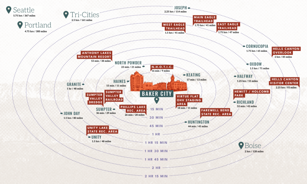
How far is it?
Things in Baker can be spread out. Know before you head out and be prepared. If you can’t visit everything on your list, that’s ok! We’ll be here waiting for your next visit.
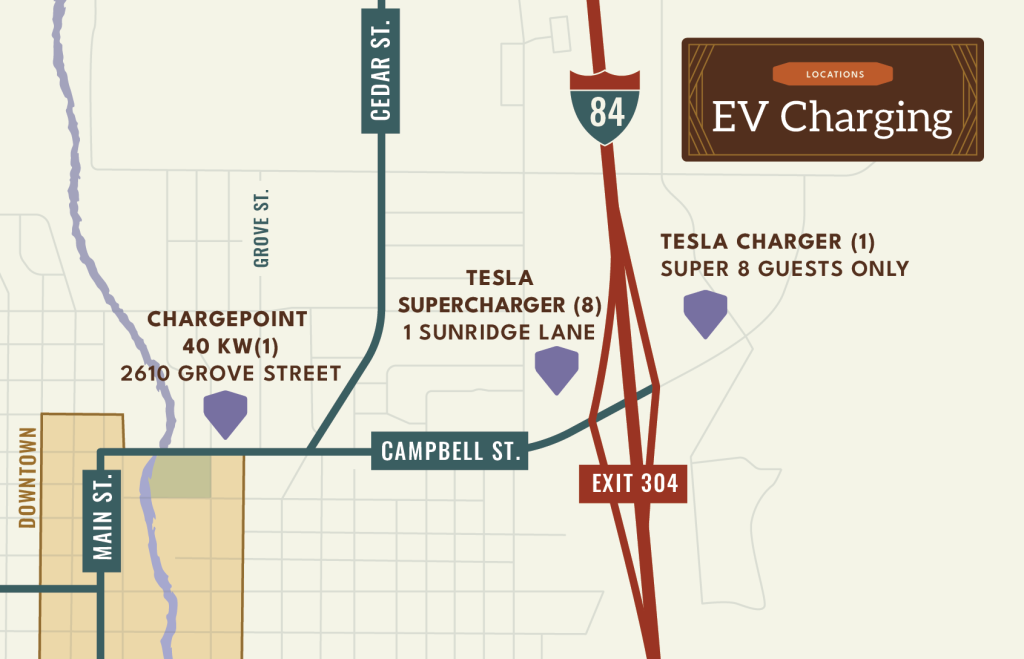
Electric vehicle charging
charging locations
Those looking for EV charging have a few options in Baker City. There are eight chargers by the Best Western just off I-84 on Campbell St, and additional charging at the Armory on Grove and at the Super 8.
Several RV parks also have charging stations.